


LIBERTY TWP Voting District, Wood County, Ohio
About
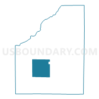
Outline

Summary
| Unique Area Identifier | 653341 |
| Name | LIBERTY TWP Voting District |
| County | Wood County |
| State | Ohio |
| Area (square miles) | 36.26 |
| Land Area (square miles) | 36.22 |
| Water Area (square miles) | 0.04 |
| % of Land Area | 99.88 |
| % of Water Area | 0.12 |
| Latitude of the Internal Point | 41.30184390 |
| Longtitude of the Internal Point | -83.71081440 |
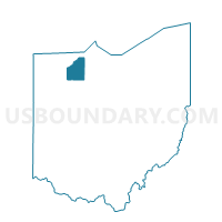
Maps

Graphs
Select a template below for downloading or customizing gragh for LIBERTY TWP Voting District, Wood County, Ohio


Neighbors
Neighoring Voting District (by Name) Neighboring Voting District on the Map
- BLOOM TOWNSHIP Voting District, Wood County, OH
- CENTER TOWNSHIP Voting District, Wood County, OH
- HENRY TWP HAMMANSBURG Voting District, Wood County, OH
- JACKSON TWP Voting District, Wood County, OH
- MILTON TWP NORTH Voting District, Wood County, OH
- MILTON TWP SOUTH Voting District, Wood County, OH
- PLAIN TWP Voting District, Wood County, OH
- PORTAGE TOWNSHIP Voting District, Wood County, OH
- PORTAGE VILLAGE Voting District, Wood County, OH
- WESTON TWP WILLOW Voting District, Wood County, OH
Top 10 Neighboring County Subdivision (by Population) Neighboring County Subdivision on the Map
- Henry township, Wood County, OH (4,175)
- Bloom township, Wood County, OH (2,609)
- Weston township, Wood County, OH (2,336)
- Liberty township, Wood County, OH (1,766)
- Plain township, Wood County, OH (1,663)
- Portage township, Wood County, OH (1,614)
- Center township, Wood County, OH (1,206)
- Milton township, Wood County, OH (979)
- Jackson township, Wood County, OH (792)
Top 10 Neighboring Place (by Population) Neighboring Place on the Map
Top 10 Neighboring Unified School District (by Population) Neighboring Unified School District on the Map
- Bowling Green City School District, OH (35,618)
- Otsego Local School District, OH (9,825)
- Elmwood Local School District, OH (6,292)
- North Baltimore Local School District, OH (4,283)
Top 10 Neighboring State Legislative District Lower Chamber (by Population) Neighboring State Legislative District Lower Chamber on the Map
Top 10 Neighboring State Legislative District Upper Chamber (by Population) Neighboring State Legislative District Upper Chamber on the Map
Top 10 Neighboring 111th Congressional District (by Population) Neighboring 111th Congressional District on the Map
Top 10 Neighboring Census Tract (by Population) Neighboring Census Tract on the Map
- Census Tract 225, Wood County, OH (4,198)
- Census Tract 223, Wood County, OH (3,964)
- Census Tract 214, Wood County, OH (3,315)
- Census Tract 215, Wood County, OH (2,453)
Top 10 Neighboring 5-Digit ZIP Code Tabulation Area (by Population) Neighboring 5-Digit ZIP Code Tabulation Area on the Map
- 43402, OH (31,327)
- 43569, OH (2,818)
- 43413, OH (1,407)
- 43462, OH (1,163)
- 43451, OH (1,119)
- 43511, OH (940)